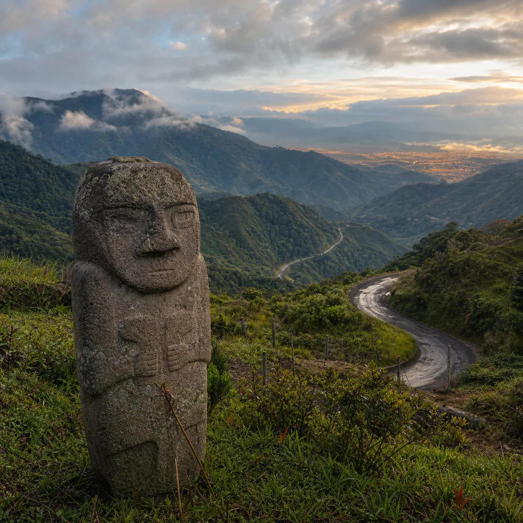
Colombia’s Southern Andes reward travelers who stop measuring a journey only in kilometres. A road can leave the dry ochre labyrinths of Tatacoa, climb toward ancient stone guardians in San Agustín, cross green mountain country to Popayán, and continue through the highlands of Nariño to a basilica suspended above a canyon. The landscapes change quickly; the travel days do not. This north-to-south itinerary is designed as a realistic 10–14 day planning framework, not as turn-by-turn navigation.
The five principal stops already have detailed destination guides. This route connects them into one story about archaeology, regional food, Andean culture, and changing altitude. It also makes the difficult part visible: several transfers deserve most or all of a day, and mountain conditions can invalidate a tightly scheduled plan.
Stage One: Tatacoa to San Agustín
Begin in Neiva or Villavieja and give the Tatacoa Desert at least one full day and one night. Tatacoa is technically a tropical dry forest shaped by erosion, not a sand desert. Its red gullies, grey formations, intense heat, and dark skies make it a striking first chapter. Walk early or late, carry more water than you expect to need, and arrange local transport if you want to visit sectors that are impractical on foot.
Colombia Travel recommends approaching the area through Villavieja and describes walking, local transfers, and tours as ways to explore it. Confirm astronomy sessions and local departure times after arrival rather than treating an old timetable as fixed. The following morning, return through Villavieja and travel south through Huila. Keep the entire day available for San Agustín; a same-day archaeological park booking would leave too little margin.
Spend two or three nights around San Agustín, then use our archaeological landscapes guide to shape the visit. The main park deserves an unhurried visit, but the wider region also includes Alto de los Ídolos, Alto de las Piedras, river viewpoints, farms, and rural roads. The monuments are not decorative props: they belong to complex funerary and ceremonial landscapes. Follow site rules, avoid touching sculptures, and use an informed local guide when you want historical context beyond the labels.
Stage Two: San Agustín to Popayán
The crossing from San Agustín toward Popayán is one of the route’s defining transitions and should be treated as a full travel day. It links Huila’s archaeological zone with the high country of Cauca, but weather, works, traffic restrictions, and the condition of mountain roads can extend the journey. Choose an established intercity service or a reputable private transfer, travel in daylight, and avoid a non-refundable event or flight on arrival day.
After the road, allow at least two nights for Popayán. The historic centre is more than its white façades: markets, bakeries, traditional cooks, religious heritage, and nearby Indigenous and campesino foodways give the city its depth. Try regional preparations deliberately rather than reducing the stop to a photograph of the centre. Silvia needs separate time; do not add Puracé National Park while its visitor sectors remain temporarily closed for volcanic risk.
Stage Three: Popayán to Pasto and Las Lajas
The road from Popayán to Pasto is another substantial intercity transfer. Leave early, keep food and water accessible, and preserve the evening as recovery time. Pasto sits at a noticeably higher altitude and can feel cold after Huila and Popayán. Two nights let you explore the city’s workshops, local dishes, and the layered cultural history described in our Pasto and Carnaval de Negros y Blancos guide.
If you travel around the January carnival, reserve accommodation and transport well ahead and expect normal circulation to change. Outside the festival, the city is still worth the stop: artisans, museums, Andean ingredients, and views toward the surrounding highlands connect the route’s archaeological beginning with living creative traditions.
Finish at the Santuario de Las Lajas near Ipiales. Travel south from Pasto, leave luggage securely in Ipiales if necessary, and use local transport to reach the sanctuary access area. The final approach descends into the Guáitara canyon, so allow time for the walkway, cool or wet weather, and the climb back. Confirm return transport before descending, especially late in the day.
Flights, Roads, and Realistic Pacing
A practical open-jaw version starts with a flight to Neiva and ends with a departure from the Pasto or Ipiales area, subject to current schedules. Those flights are gateways, not shortcuts between the route’s five ordered stops. The itinerary itself is overland, and its map line is an editorial sequence rather than a live road recommendation.
A balanced plan uses two nights around Tatacoa, two or three in San Agustín, two in Popayán, two in Pasto, and one or two around Ipiales, plus three protected transfer days. With only ten days, remove optional side trips and accept early departures. With 12–14 days, weather buffers and slower cultural visits make the journey much more enjoyable.
Before every long leg, consult the official INVÍAS road status service and ask the operator to confirm the departure. Never assume a duration quoted months earlier will still apply. This is especially important when a domestic flight, international border movement, or prepaid reservation follows the road transfer.
Practical Tips for the 2026 Southern Andes Route
- Verify archaeological access: Check the current ICANH admission rates, entry window, and scheduled closure calendar before committing to a park day.
- Travel mountain roads by day: Prefer established transport, keep arrival evenings flexible, and check INVÍAS immediately before departure.
- Pack for several climates: Tatacoa can be extremely hot, while Pasto and Ipiales are cool and wet. Sun protection, a light waterproof layer, warm clothing, and shoes with grip all earn their place.
- Keep luggage manageable: Stairs, local transfers, bus terminals, and the Las Lajas walkway are easier with one compact bag and a secure daypack.
- Respect living heritage: Ask before photographing people, buy directly from artisans when possible, and approach Indigenous or community spaces as a guest rather than an observer entitled to access.
- Protect a buffer day: Place it before a fixed flight or border crossing, not at the beginning when every schedule still appears perfect.
This journey works because the contrasts are real: arid earth and clouded mountains, ancient funerary sculpture and contemporary workshops, white colonial streets and a dramatic canyon sanctuary. It works even better when time is treated as part of the experience. Build around full travel days, verify conditions, and let each destination remain more than a marker joined by a line.
🕵️ Insider Secrets
- Watch the light twice in Tatacoa: Red formations are most expressive near sunrise and sunset, while the night sky provides a completely different experience. Staying overnight avoids compressing both into a rushed day trip.
- Separate museum time from transfer time: Visit the San Agustín park on a complete morning or afternoon and depart for Popayán on another day. The monuments deserve attention, and the mountain road deserves margin.
- Use food as the route’s timeline: Compare Huila flavours, Popayán’s culinary traditions, and Nariño’s highland ingredients. The progression explains geography as clearly as the changing temperature.
- Do not race the canyon: Las Lajas is most memorable when you can descend, cross the bridge, look back from several levels, and return without watching the final transport minute by minute.
eSIM for Colombia
Avoid high roaming fees. Get instant 4G/LTE data with Airalo as soon as you land in Bogotá or Medellín.
- Instant Activation
- No Physical SIM Card
- Local & Regional Plans