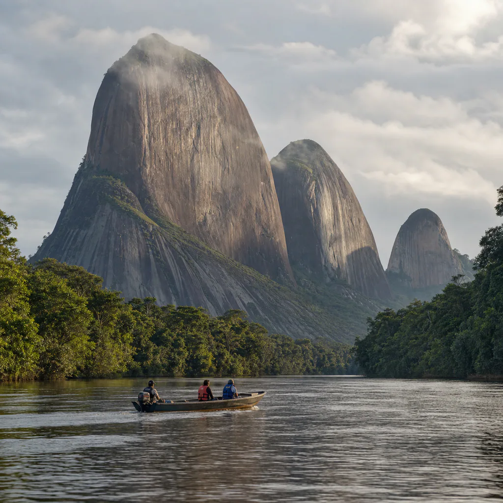
The Cerros de Mavecure appear above the forest like enormous stone islands. Mavecure, Mono, and Pajarito rise beside the Inírida River in Guainía, within an ancient geological landscape shared with Indigenous communities. Reaching them requires more than booking a viewpoint: the journey begins in Inírida, continues by boat, and depends on local knowledge, river conditions, and permission to enter community territory.
Plan at least three nights in the region in 2026. Keep the arrival and departure days in Inírida, then reserve one full day or an arranged overnight for Mavecure. Flights, boats, weather, and water levels can shift, so a tight connection with no buffer is a poor fit for this remote corner of Colombia.
Begin in Inírida with a Confirmed Operator
Inírida is the practical gateway and the place to confirm transport, food, accommodation, guides, and community arrangements. ProColombia's official Guainía guide places the hills about fifty kilometers from the departmental capital and identifies the area as part of a wider river-and-forest territory shaped by Puinave and other Indigenous communities.
Reserve before flying rather than looking for an informal boat at the riverbank. Ask for the operator's legal name, guide, departure point, boat type, life jackets, emergency plan, fuel allowance, meals, drinking water, community fees, and return conditions. Clarify whether the trip is a long day excursion or includes a hosted overnight. The cheapest quote may omit the very elements that make the route safer and more beneficial locally.
Let the River Set the Pace
The approach along the Inírida River is part of the experience. Forest, exposed rock, beaches, channels, and currents change with the season. Colombia Travel's Mavecure access guide describes a fast-boat journey south from Inírida, but actual duration varies with the vessel, water level, stops, and weather. Treat any quoted time as an estimate.
Wear the life jacket for the entire crossing, protect electronics in a dry bag, and keep essential medication on your body rather than in loose luggage. Sit where the boat crew indicates and avoid standing for photographs while moving. If rain, wind, low water, or rapids alter the plan, let the pilot and community guide decide whether to continue, wait, or turn back.
Understand the Three Hills Before Climbing
Mavecure, Mono, and Pajarito belong to the Guiana Shield, an ancient geological formation extending beyond Colombia. The official Cerros de Mavecure tourism page presents them as a connected landscape rather than three interchangeable summits. Their scale becomes clearest from the water and the lower forest, where dark rock contrasts with river reflections and dense vegetation.
Do not assume every hill is open to visitors. Official tourism guidance commonly identifies Mavecure as the permitted ascent, but access, route limits, weather closures, and community decisions can change. Follow the guide's instructions on the day. Bare rock becomes dangerous when wet, shade is limited, and tropical heat can make a short distance demanding. Turning around is a sound decision, not a failed visit.
Keep footwear on, carry water, and leave plants, stones, and markings untouched. Drones require explicit community and aviation permission and can disturb people and wildlife. The most responsible image may be taken from the riverbank instead of a summit.
Visit El Remanso on the Community's Terms
El Remanso is not a service stop built for travelers. It is a living community whose residents host selected experiences and help protect the surrounding territory. A community-led visit may include a meal, local interpretation, crafts, stories, or accommodation, but only what has been agreed should be expected.
Ask before photographing people, homes, children, ceremonies, crafts, or sacred places. Do not press for performances, private knowledge, or access beyond the route. Pay the stated community and guide fees, buy directly when invited, and learn how income is distributed. Respect also means accepting a refusal without negotiation.
Add Inírida Without Overloading the Trip
Keep a separate day for Inírida and nearby river experiences rather than attaching every attraction to the Mavecure outing. The region includes the Inírida flower, Indigenous craft initiatives, lagoons, and the internationally recognized wetlands of the Estrella Fluvial Inírida. The Ministry of Environment emphasizes that conservation of this river system is closely connected to community participation.
Ask local operators which activities fit the current season and which spaces are receiving visitors. River beaches, channels, wildlife observations, and travel times can look very different across the year. Leave one flexible half-day before your return flight instead of building the itinerary around a final morning boat ride.
Practical Tips
- Book before arrival: Confirm the licensed operator, community host, guide, boat, inclusions, and cancellation terms in writing.
- Protect against water and sun: Bring a dry bag, quick-drying layers, secure hat, sunscreen, insect repellent, and refillable bottle.
- Carry essential cash: Connectivity and card payments may be unreliable outside Inírida.
- Pack light: Boat crews may limit luggage, especially when water levels affect navigation.
- Keep a flight buffer: Spend the final night in Inírida and avoid same-day river-to-airport connections.
- Follow the day's permissions: Community rules and weather conditions take priority over an online itinerary.
🕵️ Insider Secrets
- Watch from the water first: The relationship between all three hills is easier to understand before approaching a trail.
- Use a small camera setup: Heat, spray, and steep rock make heavy equipment more burden than advantage.
- Ask about river color: A local guide can explain how different waters, sediments, and seasons shape the landscape.
- Leave the summit optional: Mist, reflections, community conversation, and the river journey can become the strongest parts of the day.
- Listen after dark: On an approved overnight, quiet observation reveals the forest without chasing or spotlighting wildlife.
Mavecure is memorable because the route, the river, the rock, and the community cannot be separated. Arrive with time, use a responsible local operator, accept changing conditions, and let your hosts define the boundaries of the visit. That approach turns a remote photograph into a more honest encounter with Guainía.
eSIM for Colombia
Avoid high roaming fees. Get instant 4G/LTE data with Airalo as soon as you land in Bogotá or Medellín.
- Instant Activation
- No Physical SIM Card
- Local & Regional Plans