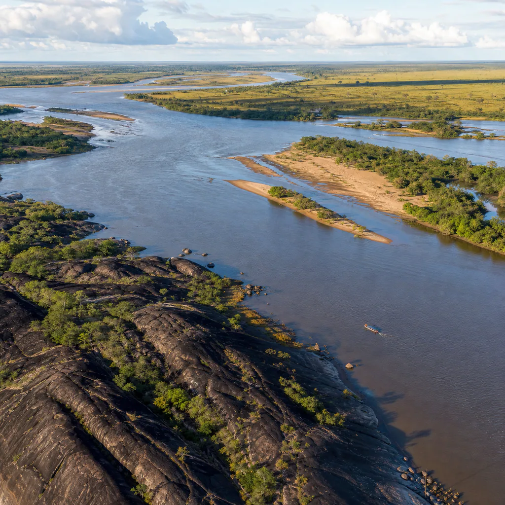
Puerto Carreño feels less like the end of a route than the beginning of a larger landscape. At Colombia's eastern edge, the Meta River meets the Orinoco beside warm streets, granite hills, gallery forest, and plains that continue across the Venezuelan horizon. Water determines the rhythm here: boats carry people and supplies, river levels reshape access, and memorable views return to the channels surrounding the city.
This is not a quick extension to a standard itinerary. Heat, seasonal conditions, and long boat journeys reward travelers who plan carefully. In return, Puerto Carreño offers a rare introduction to the northern Orinoquia, where Indigenous cultures, llanero traditions, ancient geology, and important wetlands meet.
Where Two Great Rivers Meet
The official Puerto Carreño municipal profile places the city at the confluence of the Meta and Orinoco rivers, only 51 metres above sea level. The setting explains both its frontier character and its importance as a river port. Walk the riverfront slowly, watching the color, current, islands, and boat traffic change as the day warms.
The national Colombia Travel guide to Puerto Carreño highlights three waterways: the Orinoco, Meta, and Bita. Excursions may include confluence viewpoints, seasonal river beaches, wildlife observation, or a small-boat outing. Pink river dolphins live in this system, but sightings are never guaranteed. Choose an operator who observes from a respectful distance.
Granite Hills Above the Plains
Puerto Carreño's dark rock outcrops are fragments of the ancient Guiana Shield rising abruptly above otherwise horizontal country. Cerro de la Bandera is the most accessible introduction. Its summit overlooks the town, river corridors, and plains across the border, making early morning a better choice than the hottest part of the day. The climb is short, but exposed rock becomes punishing under direct sun and slippery after rain.
Pause to see how gallery forest follows the waterways while open savanna occupies higher, drier ground. From above, Puerto Carreño makes geographic sense: settlement, transport, and daily life gather where rock and river create a usable edge.
The Bita Is More Than a Boat Trip
South of town, the Bita flows into the Orinoco through one of Colombia's most significant freshwater landscapes. A February 2026 update from Corporinoquia on the Bita Ramsar wetland describes a free-flowing river basin connected to more than 5,000 streams and tributaries. The watershed was designated a Wetland of International Importance in 2018, recognizing its biodiversity and exceptional conservation value.
Approach a Bita excursion as environmental interpretation, not a wildlife checklist. Ask where the boat may travel, how seasonal water affects access, and what observation rules apply. Carry every piece of waste back, keep music off, and avoid requesting close encounters with dolphins, turtles, or nesting birds. A quiet journey through morichales, sandbanks, forest edges, and open water is the attraction.
El Tuparro Requires Real Planning
Puerto Carreño is the main arrival point for travelers heading toward El Tuparro National Natural Park, but the park is not beside the city. Reaching its savannas, granite formations, and powerful rapids requires a long organized journey by river or, in suitable dry-season conditions, by road. Treat it as a separate expedition rather than a casual afternoon excursion.
The official El Tuparro visitor page lists the park as open at the time of writing, while requiring visitors to confirm capacity, dates, reservations, insurance, and an authorized guide or interpreter before travel. Conditions and permissions can change. The park does not allow overnight stays inside the protected area, and its services are separate from the entry process, so confirm the complete itinerary directly with an authorized operator before booking flights around it.
Build a Flexible Puerto Carreño Stay
Most visitors arrive by air at Germán Olano Airport. Avoid treating arrival and departure days as tightly scheduled tour days: weather, river levels, and flight changes can affect remote travel. Three nights allow time for the town, a granite viewpoint, and one local river experience. Add several more days only after confirming an El Tuparro program or another longer reserve visit.
Accommodation is concentrated near Parque Santander, with generally simple options. Arrange boats through registered local operators and confirm what food, drinking water, safety equipment, and insurance are included. Spending on local lodging, guiding, meals, and crafts is more valuable than racing through distant attractions.
Practical Tips
- Confirm every remote outing: Recheck the operator, route, river level, meeting point, return time, and weather shortly before departure.
- Plan for intense heat: Carry more drinking water than expected, use high-SPF sunscreen, wear a brimmed hat, and schedule exposed walks early.
- Ask about health requirements: Consult current official guidance on yellow fever and other vaccinations before flying or entering protected areas.
- Use proper river safety: Wear the provided life jacket, keep electronics in a dry bag, and never assume calm-looking water is safe for swimming.
- Bring cash and backups: Card acceptance, mobile data, and cash availability can be less reliable outside the town center.
- Pack out single-use items: Protected river landscapes have limited waste infrastructure, so reduce packaging before each excursion.
🕵️ Insider Secrets
- Climb before breakfast: Cerro de la Bandera is cooler and clearer near sunrise, when the rivers and Venezuelan plains emerge gradually.
- Return to the water at dusk: Late light reveals currents, sandbars, and boat silhouettes that disappear under the midday glare.
- Ask which river you are seeing: Understanding the Meta, Orinoco, and Bita turns a scenic boat ride into a lesson in the region's geography.
- Listen for local music: Joropo, harp, cuatro, and maracas connect Puerto Carreño to the wider cultural landscape of the plains.
- Leave one unscheduled window: A free half-day protects the trip from weather changes and often becomes the best time for an unhurried local meal or river walk.
Puerto Carreño rewards attention rather than speed. Its scale becomes visible from a granite hill, its biodiversity becomes understandable on a quiet river, and its remoteness becomes part of the journey rather than an inconvenience. Plan conservatively, hire locally, respect changing conditions, and Colombia's eastern frontier will feel expansive without ever needing to be exaggerated.
eSIM for Colombia
Avoid high roaming fees. Get instant 4G/LTE data with Airalo as soon as you land in Bogotá or Medellín.
- Instant Activation
- No Physical SIM Card
- Local & Regional Plans